Svalbard - Spitsbergen 2008
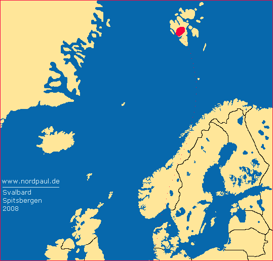
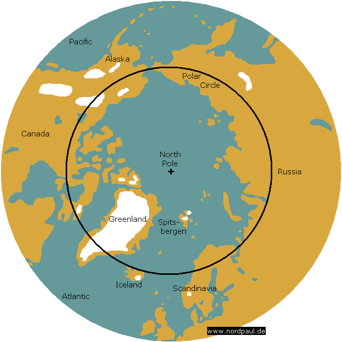
The archipelago Svalbard: former home of polar explorers, adventurers and discoverers. Far away from Central Europe. Just a dream. In younger age I only read from Spitsbergen. In August 2008 I was there for twelve days and twelve bright nights.
Since many years expensive cruisers go already far to the north to the icy polar cap - and also to Spitsbergen. For such a tour it was necessary to save a lot of money. In summer 2007 I saw incidentally that flights to Spitsbergen and tenting at the campsite (next to the air field, 90 NOK in 2008) could be a surprising affordable combination for having a great time near the end of the world. A word (an idea) and a blow.
It was bright. It was cold. It was an adventure.
 |
 |
 |
 |
 |
 |
| Airfield |
Tent |
Bird's view |
Frost |
far away |
Isfjord |
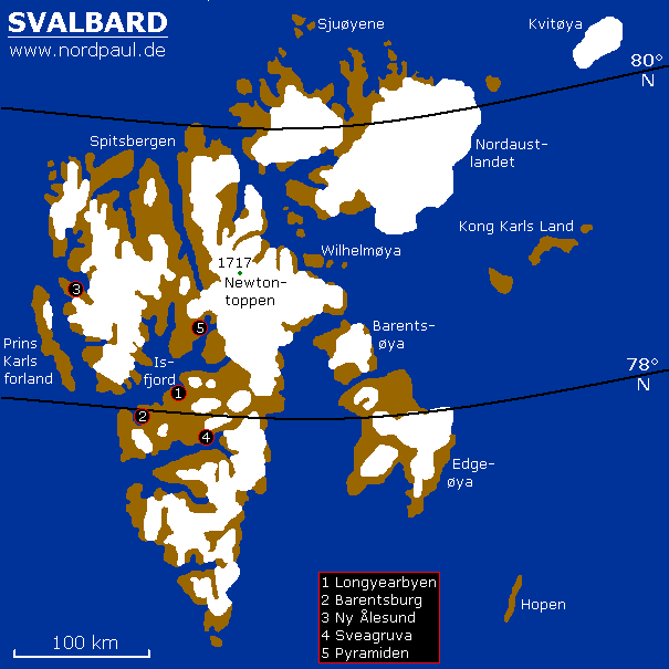
There are different names for the archipelago. Sometimes it is called "Spitsbergen". The Norwegians who have the sovereignty of the islands say "Svalbard". (Vest-)Spitsbergen is actually the largest and the only inhabited island.
The most important settlemet is the Norwegian city Longyearbyen which is situated inside the Longyeardal and along the Adventfjord. And this fjord is the flooded end of the Adventdal. It flows into the large Isfjord. Apart from Longyearbyen you find two more Norwegian settlements and one of former two Russian cities.
 |
 |
 |
 |
 |
 |
| Adventfjord |
Hiorthhamn |
Coal harbour |
Longyearbyen |
Districts |
the valley |
At the turn of the second last century many mining companies were in search of mineral resources on Spitsbergen. They builded the first coal mines into the mountains.
The coal seam was 80 to 120 cm thick and in about 300 to 400 m above the sea level of the fjords. Therefore the mined coal only needed to be transported from the mountainside down to the harbour. That has been done by aerial cableways for centuries. Still today the wooden pillars characterize the view of this place.
 |
 |
 |
 |
 |
 |
| good coal |
Mine 1 |
Mine 2 |
Longyeardal |
Cableway |
Coal transport |
The risk of meeting a polar bear outside of Longyearbyen is the reason to take a proper gun with you on hiking tours. On guided trips the guide takes the necessary technical equipment and experience with himself. Meanwhile many tour organisers offer you hours, day and longer tours in and around Longyearbyen.
 |
 |
 |
 |
 |
 |
| Adventdalen |
Poppy |
Larsbreen |
Trollsteinen |
Svalsat |
old snow |
The weather was somewhat colder and wetter in August 2008 than on average. The temperature was all the time below 10 degrees. In the mountains we had sometimes frost at night. Precipitation in a kind of drizzle or steady rain was not rare. One morning there was snow around and on the tents. And the word "night" means in summertime "sunshine somewhat over the horizon". Darkness you just find inside the coal mines.
On the one hand Spitsbergen in general is pure wilderness, on the other hand Longyearbyen is a small village like every other in Northern Europe: with a supermarket, a post office, restaurants, schools, some outdoor shops and a library.
 |
 |
 |
 |
 |
 |
| Ice view |
Reindeer |
Hiorthfjellet |
Coal mine |
at the top |
Adventdelta |
Different ships offer day trips to fjords and glaciers in the surrounding. On the way to the Russian settlement Barentsburg for example the ship stops first at the glacier edge of the Esmarkbreen. Not expected and therefore very surprisingly I saw one polar bear at the shore near the glacier.
 |
 |
 |
 |
 |
 |
| Polargirl |
Esmarkbreen |
Ship size |
the Bear |
Barentsburg |
Russian |
Having seen the bear a moment ago we (five persons) started a four days hike across the wilderness from Barentsburg back to Longyearbyen. If everything goes right...
And at night we had the "relaxed" feeling that the signal wire around the tents and the rockets make this place saver from polar bears.
It was a nice tingling after had been crossing knee-deep the hardly more than 0 degree C cold river. And the blood circulation was activated again inside the naked feet.
 |
 |
 |
 |
 |
| Warning |
on and on |
Tents |
Wire |
Crossing |
When waking up after the second night in the wilderness everything seemed so bright. Opening the tent is showing the result: it had been snowing for hours. The deep rutted mountains with its endless pebble deserts are for themselves hardly describable or subsumable. But with a fresh white snow cap at the tops they appear in a totally different way. It is August.
 |
 |
 |
 |
 |
 |
| Snow night |
Hiking |
Colesdalen |
Synndalen |
icy mountains |
Grumantbyen |
During the four hiking days we did not see any more polar bears. Also at night nobody was apparent around the tents. On the last of the four days we saw new footprints of a bear on a snow field. Later I heard that a young polar bear had to been shot not far away from us while he had attacked a person.
 |
 |
 |
 |
| August |
Plateau |
NASA |
Lighting |
The second boat trip led me into the east to one end of the Isfjord and the Russian settlement Pyramiden and the eponymous mountain beyond it. But this time without a following hiking tour for myself. For a long time Pyramiden was the second Soviet settlement on Spitsbergen. Some years ago it was abandoned. Today it is a ghost town.
 |
 |
 |
 |
 |
| 2nd tour |
Pyramiden |
Soviet |
Gull city |
Coal inside |
 |
 |
 |
 |
| History |
old times |
near 80 deg |
Water way |
After the guided tour through Pyramiden the boat trip continued to the large glacier Nordenskjøldbreen. During this trip I reached my (temporary) northernmost position in 78 degrees and 40 minutes North. Most of the discoverers and explorers just started in these latitudes in the last centuries. And this without the today's technical equipment.
 |
 |
 |
 |
 |
| Course |
Fjord end |
Nordenskjø. |
Weather |
Snow cap |
On the way back to Longyearbyen I saw one of the most beautiful and formidable mountain landscape in my life. From the ship I admired Bünsowland with its snow covered craggy rock faces. When will I come back to Spitsbergen?
When will I come back to Svalbard? For how long Spitsbergen will still look like today?
If you want you can correct my English because it is not my native language.
Just send me an e-mail: webmaster@nordpaul.de
 |
 |
 |
 |
 |
| Billefjord |
Snow ridge |
Bünsowland |
steep |
craggy |
» Links
Last modified: 2018/04/26
♥ Privacy means: no tracking, no cookies, no third-party ad servers or ad networks. ♥
© nordpaul.de - Pictures of Northern Europe
- nordpaul.de - North Europe - Site Terms - [deutsch] -
Svalbard Spitsbergen Longyearbyen Isfjord Adventdal coal polar bear snow fjord glacier Barentsburg Esmarkbreen Colesdal Pyramiden Nordenskjøldbreen Bünsowland


